If you research land records, survey plats, or historic deeds in Colorado, you will inevitably encounter legal land descriptions that look like an alphanumeric code: SW¼ NE¼ Sec. 14, T3S, R68W, 6th P.M.
This string of characters is the language of the Public Land Survey System (PLSS). Originally designed to bring order to the distribution of western lands, the PLSS remains a foundational framework for describing much of Colorado’s land. Recorded subdivisions, metes-and-bounds descriptions, land grants, and special surveys also matter; not every property is described solely by a rectangular PLSS reference.
However, translating a written legal description into a physical location on the ground can be cumbersome if you are relying solely on text-based records. In our foundational guide on how to find Colorado section corner records, we established the importance of spatial context. This guide breaks down exactly how to read a PLSS description, how the grid functions, and how you can use Topo Colorado’s PLSS Monument Records map to view this survey context. Map linework helps orient research; it does not determine a property boundary.
The Starting Point: Meridians and Baselines
Before you can measure a distance, you need a starting point. In the PLSS, that starting point is the intersection of two primary lines:
- Principal Meridian: A true north-south line.
- Baseline: A true east-west line.
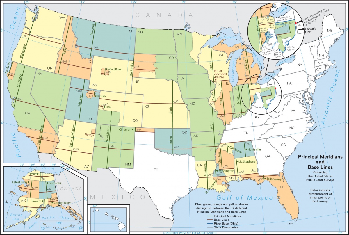
Township and range designations identify tiers and columns relative to these reference lines; they are not precise distance coordinates. Colorado research includes the Sixth Principal Meridian, New Mexico Principal Meridian, and Ute Principal Meridian systems. Always carry the correct meridian through the description: the same township and range numbers can occur in different systems. The BLM principal-meridian map provides regional context.
What is a Township?
The term "Township" is used in two ways within the PLSS, which often causes confusion.
- Township as a Measurement (The Y-Axis): Township lines run east-west, parallel to the baseline. They define nominal six-mile tiers north or south of the baseline. For example, Township 3 South (T3S) is the third six-mile tier south of the baseline.
- Township as an Area: When combined with a Range, a "Township" refers to a nominally 36-square-mile block of land (six miles by six miles).
What is a Range?
Range lines generally follow a north-south direction. Range designations identify nominal six-mile columns east or west of the principal meridian. Think of this as the grid’s east-west address, not a perfectly parallel Cartesian X-axis: meridians converge, and the survey system includes corrections.
For example, Range 68 West (R68W) is the 68th six-mile column west of the Principal Meridian.
The intersection of a township tier and a range column identifies a nominal 36-square-mile township. T3S, R68W becomes geographically meaningful only with the state and principal meridian specified. Actual survey dimensions can differ from the nominal grid.
| Tier | R69W | R68W | R67W |
|---|---|---|---|
| T2S | Township | Township | Township |
| T3S | Township | T3S, R68WSelected township | Township |
| T4S | Township | Township | Township |
What is a Section?
Because a 36-square-mile block is too large for most land conveyances, Townships are subdivided into 36 Sections.
A standard section is nominally one mile square and contains roughly 640 acres.
The numbering system for sections within a Township follows a specific "snaking" pattern (boustrophedonic sequence) established by the federal government:
- In the standard rectangular arrangement, Section 1 begins in the northeast corner of the Township.
- The numbers count westward to Section 6.
- The sequence drops down one tier to Section 7 and counts eastward to Section 12.
- This back-and-forth pattern continues until it terminates at Section 36 in the southeast corner.
When researching historic federal survey records—such as BLM General Land Office (GLO) plats—understanding this sequence is critical for locating the correct corner without a modern map interface.
| 6 | 5 | 4 | 3 | 2 | 1Start |
| 7 | 8 | 9 | 10 | 11 | 12 |
| 18 | 17 | 16 | 15 | 14Example | 13 |
| 19 | 20 | 21 | 22 | 23 | 24 |
| 30 | 29 | 28 | 27 | 26 | 25 |
| 31 | 32 | 33 | 34 | 35 | 36Finish |
Subdividing the Section: Aliquot Parts
Sections are routinely broken down further into aliquot parts—subdivisions expressed as halves or quarters, and further combinations of those fractions. The fractions identify survey subdivisions, not a guarantee of equal measured acreage.
- Quarter Sections: A section is divided into four quarters (Northeast, Northwest, Southeast, Southwest). A quarter section is nominally 160 acres.
- Quarter-Quarter Sections: Each 160-acre quarter can be divided into four 40-acre quarters (e.g., the Southwest Quarter of the Northeast Quarter).
The Secret to Reading Legal Descriptions: Read Backward
For a compact nested aliquot description, work from the largest reference down to the smallest part. This often means reading the reference groups from right to left. It is a locating aid for this format, not a rule for interpreting every deed, exception, or metes-and-bounds description.
Let’s decode our illustrative Colorado example: SW¼ NE¼ Sec. 14, T3S, R68W, 6th P.M. This explains the notation; it is not a verified parcel or document match.
- 6th P.M.: Confirms we are working off the Sixth Principal Meridian in Colorado.
- T3S, R68W: Identifies the township, nominally 36 square miles.
- Sec. 14: Selects Section 14 within that township, nominally one square mile or 640 acres.
- NE¼: Selects the northeast quarter of Section 14, nominally 160 acres.
- SW¼: Selects the southwest quarter of that northeast quarter, nominally 40 acres. The survey and records establish the actual subdivision.
Section 14 North ↑
Inside its NE¼ North ↑
Fractional Sections and Government Lots
In a perfect theoretical grid on a flat plane, every section would be exactly one square mile. Because the earth is curved, true north-south meridian lines converge as they travel toward the poles.
Under the general rectangular-survey plan, excess or deficiency is ordinarily accommodated along the north and west township boundaries. This is a useful pattern to recognize, not a universal rule for every survey.
North- and west-edge sections can contain fractional subdivisions and numbered government lots, such as Lot 1 or Lot 2. Lots also occur along meandered waters and other irregular survey boundaries. Do not assume that every edge section is lotted or that a lot has a standard acreage. Its location, shape, and recorded area must be read from the applicable survey plat. The BLM Specifications for Descriptions of Land distinguishes aliquot parts from numbered lots and illustrates their use.
Visualizing the Grid with Topo Colorado
Deciphering a legal description on paper is one skill; locating it efficiently on modern terrain is another. Topo Colorado’s platform provides a map-based starting point to view this grid natively.
Instead of counting blocks on an unreferenced GLO plat, you can use the statewide map to visualize the PLSS.
- Toggle the Layers: In the map interface, use the layer controls to turn on County boundaries, Principal Meridians, Township/Range boundaries, and Section lines.
- Zoom for Detail: As you zoom into an area of interest, township labels (e.g., T3S R68W) and section numbers (1–36) will dynamically render to prevent map clutter.
- Identify Corners: Once you have found your target section, select a relevant corner point and review its available coordinates, identifiers, and DORA research action. For historic plats and field notes, use the separate GLO research pathway; not every corner has a matched document.
If your research requires viewing aliquot (second-division) detail, historic non-mining special-survey geometry, or meandered-water survey areas, expand the optional Historic federal survey records layer group and enable Aliquots & government lots or another relevant sublayer. Aliquot detail becomes available at zoom 12.5 and above, subject to source coverage. The group and its sublayers default off; polygon availability does not mean a historic document has been automatically matched.
Free Exploration and PLSS Pro
Understanding the PLSS framework is a fundamental skill for anyone interacting with Colorado land records. You can open the Topo Colorado statewide map, pan, zoom, and toggle the township, range, and section layers entirely for free to build your geographic context.
When you are ready to take the next step—such as bridging your geographic research directly into official DORA document searches, using the available KML downloads, or utilizing field routing tools—these protected actions require Pro access. The prompt offers account and plan options; a free account alone does not unlock Pro tools. Government records remain public resources available directly from their agencies—the subscription covers Topo Colorado’s integrated workflow.
Put the PLSS Grid to Work
Start with the state and meridian, locate the township and range, find the section, and then follow the nested aliquot parts or numbered lots. Use map layers to orient the search and the actual records to verify the description. PLSS map geometry is research context, not a boundary determination or authorization to enter land.
Ready to see the grid in action?
Open the Colorado PLSS Research Map to explore the township and section layers and streamline your spatial research before creating an account.