Long before modern professionals began filing Colorado DORA monument records, federal survey crews were establishing the framework of the Public Land Survey System (PLSS) across Colorado’s challenging terrain. Historic General Land Office (GLO) survey plats and field notes remain valuable sources for understanding that work.
For a land surveyor researching an original corner, “following in the footsteps” of the original surveyor means examining the evidence of that survey—not simply navigating to a modern coordinate. The plat provides a graphic record; the field notes can supply details that the drawing alone cannot convey.
Topo Colorado’s PLSS Monument Records platform provides a geographic starting point for this research. Its optional federal layers help you establish the survey context, then continue to official Bureau of Land Management (BLM) records. Topo Colorado is an independent research interface, not a government records office.
Why Original GLO Records Matter
Modern map coordinates are useful for orientation, but they do not replace original survey evidence. Historic plats and field notes record the work that established or retraced the survey framework. Depending on the particular survey, useful details may include:
- Original monumentation: Descriptions of marked stones, wood posts, bearing trees, and other corner evidence recorded by survey crews.
- Terrain and topography: River crossings and landscape observations that help researchers compare the written record with the project area.
- Meandered water: Recorded water-related survey context. A mapped meandered-water feature should not be treated as a determination of navigability or a present-day legal water boundary.
- Special surveys: Nonrectangular survey areas, including relevant tracts, townsites, and land grants, that require closer attention than a regular grid suggests.
Read the plat and associated notes together. Check the survey identity, date, and geographic extent before deciding that a document applies to your project. Later resurveys or supplemental plats may also be relevant.
Using Topo Colorado for Historic Federal Research
Topo Colorado approaches historic research location-first. The federal layers use contemporary BLM GIS representations of the cadastral framework—not scanned original plats draped across the map. The BLM Colorado PLSS service supplies the underlying survey-context datasets.
The historic family is collapsed and off by default. To explore it:
- Open the map. Launch the statewide research map and navigate to your project area.
- Expand the historic group. Under Map Layers, turn on Historic federal survey records. Its individual sublayers begin off.
- Choose only the detail you need. Select Aliquots & government lots, Intersected survey grid, Special surveys · non-mining, or Meandered water. Zoom closer when the controls indicate that more detail is available.
- Inspect a mapped historic feature. Where geometry is available, select it and review the available survey attributes. These help orient the next stage of research.
- Continue to the source. The selected-feature panel offers Search official GLO plats and field notes, a protected research action. Carry the location references into the federal system, then locate and examine the relevant documents there.
The GLO action opens an official research pathway; it does not promise a prefilled search or an automatically matched plat. General source links are also available in the interface.
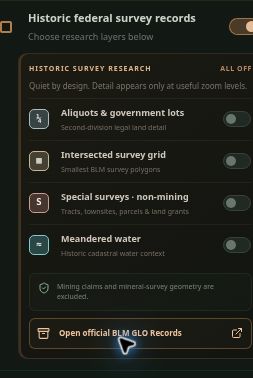
Open the group.
Choose your context.
The master group is enabled in this screenshot. Each sublayer is still off.
Turn on the detail you need, then zoom closer when prompted. This keeps the research map readable.
Map Geometry vs. Document Availability
Historic polygons and intersected-grid lines show cadastral context. They do not automatically represent verified one-to-one document matches. Selecting a feature does not establish that a particular GLO plat or field-note collection has been matched to it.
Likewise, a mapped line is not the scanned line from the original survey drawing. Confirm the survey reference, dimensions, calls, and dates in the source documents, and evaluate them alongside other relevant evidence.
A comprehensive statewide GLO metadata index, unified document-number search, and georeferenced scanned-plat overlays are not currently live features. The present workflow is map-based orientation followed by research in the official federal system.
If the records you need are not available online, consult the appropriate BLM office. BLM describes the online collection as extensive, but not complete. Its GLO overview and help guidance is a useful starting point.
| In Topo Colorado | In official GLO records |
|---|---|
| Inspect the survey area and available attributes. | Search using the relevant legal land description and survey references. |
| Use the selected feature’s protected GLO research action. | Locate the appropriate plats and field notes; compare dates and survey identity. |
| Treat mapped geometry as research context. | Review the actual documents before drawing conclusions from the map. |
A Note on Mining Claims
Topo Colorado’s historic layers focus on land-survey research and the cadastral framework. The special-survey layer excludes mining claims and mineral-survey geometry. It is not a mining-claim or mining-patent research tool.
Free Exploration and Pro Workflows
Federal BLM GLO records remain public resources available through official government portals. Topo Colorado charges for its integrated Pro workflow, not ownership of those public records.
Visitors can open the map, pan, zoom, toggle historic layers, and inspect available feature information without an account. Detailed geometry appears only at appropriate zoom levels and where the source dataset provides coverage.
Protected record actions in the selected-feature panel, supported KML downloads, and field-navigation tools require Pro access. An anonymous visitor attempting one of these actions sees account and plan options; creating a free account alone does not unlock the Pro tools. See the current PLSS Pro plans for pricing and terms.
Start Your Historic Survey Research
Historic BLM and GLO survey plats can help connect today’s research area with the survey work that shaped it. Begin with the location, identify the relevant survey references, and compare the original plat and field notes with later records and field evidence.
Ready to explore the historic framework?
Open the Colorado PLSS Research Map to inspect the optional federal survey layers before creating an account.