When conducting land-survey research or GIS mapping in Colorado, you will encounter both National Geodetic Survey (NGS) control marks and Public Land Survey System (PLSS) corners. Both may be represented by physical monuments, and both can appear near the same project area. Their research purposes are different.
PLSS research asks what evidence identifies a cadastral corner. Geodetic-control research asks how a point’s position or height relates to a defined reference system. The appearance of a disk, the precision of a displayed coordinate, or proximity to another point cannot answer both questions.
Topo Colorado’s PLSS Monument Records map lets you explore both types of information in one workspace while keeping their layers and source records distinct.
What Is a PLSS Section Corner?
The PLSS is a cadastral framework used to describe and subdivide land. Section corners, quarter-section corners, and other survey corners help define that framework. Our guide to finding Colorado section corner records explains how to begin researching them.
- Function: Identify corners within the land-survey framework. Their significance in a particular boundary depends on the controlling survey evidence and applicable law.
- Physical evidence: A corner may be marked by a historic stone or post, a later capped monument, or other documented evidence. A monument’s material alone does not establish its identity.
- Records: Research may involve Colorado DORA monument records, recorded surveys, and original or later BLM/GLO plats and field notes.
- Coordinates: A GIS point helps orient research. It does not, by itself, establish the legal corner position or prove that the physical monument remains undisturbed.
Avoid reducing boundary research to “the nearest cap wins.” A moved monument, an incorrectly identified mark, and a mapped approximation all require evaluation in context.
What Is an NGS Control Monument?
NOAA’s National Geodetic Survey maintains the National Spatial Reference System (NSRS). Its geodetic framework supports consistent positions and heights for surveying, mapping, and engineering. NGS explains the role of these coordinate references in its datums and reference frames overview.
- Function: Provide reference information for positioning and height work. Suitable control can help connect project measurements to a specified datum and mapping system.
- Physical mark: Passive marks may include disks, rods, or other documented installations. Not every mark is a disk, and a published record does not guarantee its present condition.
- Records: The official NGS record identifies the station and reports available control values, descriptive information, and recovery history.
- Quality: Accuracy varies by coordinate component and determination method. An NGS record does not automatically provide precise horizontal coordinates and a precise elevation for every mark.
For example, NGS distinguishes adjusted coordinates from positions scaled from a map. A useful vertical bench mark may have only an approximate horizontal position. Check the published source and quality information before selecting control. See the NGS explanation of survey-control data items.
The NSRS also includes active reference infrastructure such as continuously operating reference stations (CORS). Those stations are not simply another kind of passive disk to occupy. NOAA provides separate CORS data and products.
Why They Must Not Be Confused
An NGS designation alone does not establish that a mark is a property corner. A PLSS designation alone does not establish that its published coordinates are suitable project control.
If an NGS point appears near a PLSS corner, research each identity independently. Do not substitute one for the other because the symbols are close together on the screen.
The roles are not inherently incompatible. Where records and observations establish that a monument serves both purposes, evaluate each role on its own evidence. Cadastral surveys can use rigorous geodetic control; BLM’s GNSS cadastral-survey guidance describes connecting cadastral measurements to the NSRS.
The useful distinction is the purpose of the evidence—not a blanket assumption that every PLSS coordinate is imprecise or every NGS coordinate is survey-grade.
| Research question | PLSS corner | NGS control mark |
|---|---|---|
| What am I identifying? | A corner in the cadastral framework. | A station with published control information. |
| Which references matter? | Meridian, township, range, corner designation, and survey records. | PID, datum/realization, applicable epoch, and control source. |
| What must I verify? | The corner identity and supporting survey evidence. | The mark identity, condition, and suitability of each coordinate component. |
| What does proximity prove? | Neither a shared identity nor fitness for the other role. Check the records. | |
Managing the Networks on Topo Colorado
Topo Colorado organizes cadastral and geodetic research into separate map layers. PLSS subdivisions and corner points are enabled by default and appear at appropriate zoom levels. NGS control monuments and all NGS subtypes default to off.
This lets you begin with the township, range, and section context, then add control information when you need it. NGS subtypes use distinct colors and symbols, so you can read them alongside PLSS points without relying on color alone.
Activating the Optional NGS Layer
- Open the map and find your project area. Use the county selector or the map’s county/coordinate search.
- Expand NGS control monuments. Turn on the master group under Map Layers. Enabling the group does not select its subtypes.
- Choose the mark types you need. The controls offer Horizontal control, Vertical control, Combined control, CORS stations, and Other passive marks.
- Zoom closer. The interface indicates that NGS symbols load at about zoom 8.8 and above. Results depend on the selected types and available NOAA data.
- Select a point and review its attributes. Check the PID, control class, available datum/source fields, and recovery information before opening the official record.
If no symbols appear, check the subtype selections and zoom level first. A blank view does not prove that no control exists. The CORS category reflects station identifiers in the queried datasheet service; it is not a promise of complete active-network coverage or a live station-status feed.
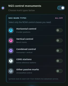
Enable the group.
Then select a subtype.
The master switch is on in this screenshot. All five mark types are still off.
Choose the control classes you need and zoom closer to display available points.
Bridging to NOAA NGS Datasheets
Selecting an NGS point opens its available information in the research panel. For a mark with a PID (Permanent Identifier), the integrated action uses that identifier to open the official NGS mark record. If an identifier is unavailable, the application provides a general authoritative-source pathway instead.
Before relying on a published value, review the following in the official record:
- Identity and condition: PID, station name, stamping, setting, description, and recovery history. An old recovery report does not establish the mark’s condition today.
- Reference information: Datum, realization, coordinate epoch where provided, projection or State Plane zone, and units.
- Height type: Distinguish ellipsoid height from orthometric height. They are not interchangeable elevations.
- Quality and origin: Horizontal and vertical determination methods, available accuracy/order information, and any superseded values or limitations.
Use the official NGS mark portal and its documentation to interpret the record. A coordinate copied from the web map or a KML export is not a substitute for these technical checks.
| Available map information | Confirm in the official record |
|---|---|
| PID, stamping, and setting | Does the description identify the actual mark you intend to use? |
| Horizontal datum, source, and order | Which realization, epoch, and determination method apply to the position? |
| Orthometric height and vertical datum | Is this the required height type and unit, with suitable quality? |
| Last recovery and condition | How recent is the report, and what must be checked in the field? |
Free Exploration vs. Pro Workflows
You can open the map, pan, zoom, select NGS subtypes, and inspect available point information without creating an account. NOAA’s source records also remain publicly available through its official services.
A Topo Colorado PLSS Pro subscription unlocks protected datasheet actions in the selected-point panel, supported KML downloads, and routing/navigation tools. An anonymous visitor attempting a protected action sees account and plan options. A free account alone does not unlock Pro tools.
KML supports geographic viewing and research planning. It is not a promised native export to every field data collector, a State Plane control file, or a coordinate-transformation workflow. Topo Colorado provides the map and integrated research tools; professional control selection still requires the source information and appropriate field checks.
Start Your Control and Corner Research
NGS control records and PLSS corner records answer different questions that often arise on the same project. Keep the identities, coordinate references, and supporting evidence clear while researching them together.
Open the Colorado PLSS Research Map to explore the optional NGS layer and its relationship to the statewide PLSS framework before creating an account.