If you have read our guide to township, range, and section, you know how these references help identify an area within the Public Land Survey System (PLSS). The next question is just as important: which survey system supplies the reference?
A principal meridian and its associated base line establish the reference for a rectangular survey system. Township designations run north or south of the base line; range designations run east or west of the principal meridian. Their intersection is the initial point.
These are survey references, not exact Cartesian distance coordinates. Actual township geometry can include corrections, fractional areas, and irregular survey boundaries. A complete research reference needs the state and meridian as well as the township, range, and relevant subdivision.
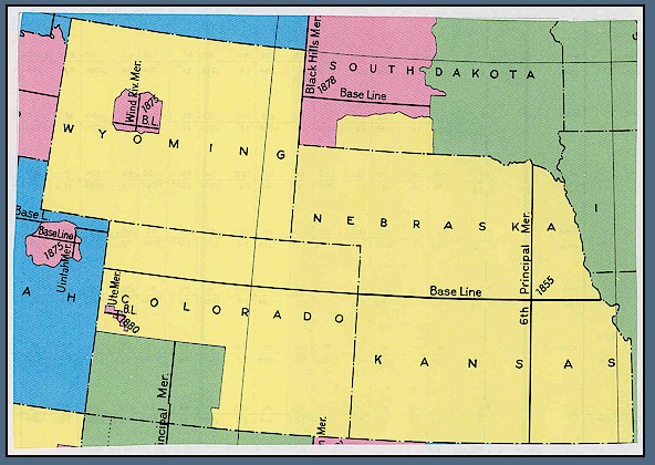
Colorado uses three principal meridian systems: Sixth, New Mexico, and Ute. Identifying the right one helps you search historic BLM/GLO records and Colorado DORA monument records. Topo Colorado’s statewide map gives you a geographic starting point for checking that context.
The Three Meridians of Colorado
The Sixth, New Mexico, and Ute systems cover different parts of Colorado’s PLSS framework. Regional descriptions help with orientation, but they should not replace the actual survey reference. Land grants, special surveys, and local survey conventions also require attention; not every tract fits neatly into a regular township grid.
1. The Sixth Principal Meridian (6th P.M.)
The Sixth Principal Meridian governs most of Colorado, including much of the Front Range, eastern plains, and northern mountain region. Its initial point is on the Kansas–Nebraska boundary, east of Colorado, and its base line extends westward through northern Colorado at approximately 40 degrees north latitude. The USGS regional meridian map shows this relationship.
Colorado has Sixth Principal Meridian townships both north and south of the base line. Do not assume that every Colorado township in this system is designated South. Colorado ranges in the Sixth Principal Meridian system are west of the meridian.
For a documented example, BLM’s 2020 Colorado survey-filing notice identifies Township 1 North, Range 102 West, Sixth Principal Meridian, Colorado. A North township designation is therefore not a reason to reject a Colorado Sixth Principal Meridian search.
2. The New Mexico Principal Meridian (N.M.P.M.)
The New Mexico Principal Meridian governs substantial areas of southern and southwestern Colorado, including PLSS survey areas in the San Luis Valley and San Juan region. Its initial point and base line lie in New Mexico, south of Colorado. The BLM principal-meridian map provides broader regional context.
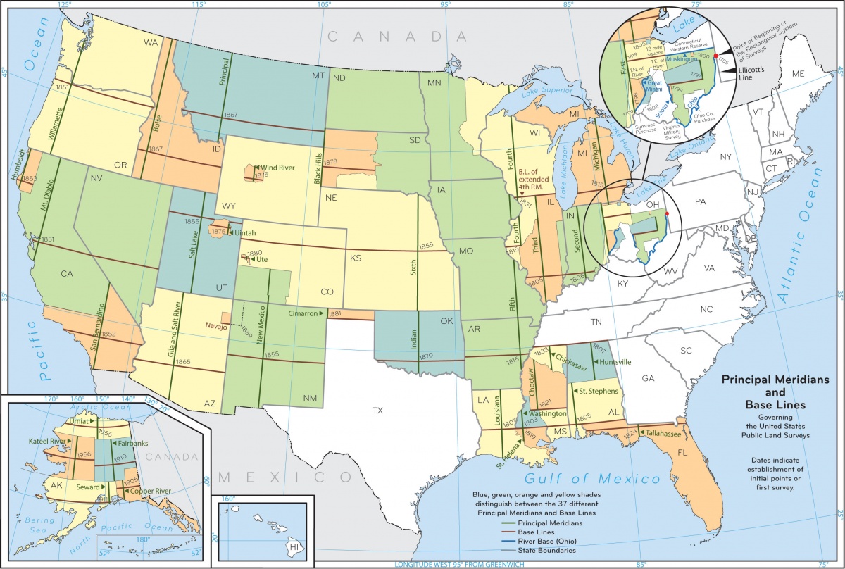
Colorado townships in this system are designated North. Ranges can be East or West of the meridian. For example, the same BLM filing notice identifies Township 36 North, Range 1 West, New Mexico Principal Meridian, Colorado.
Township 1 North in the New Mexico system is near that system’s base line in New Mexico—not just above the Colorado–New Mexico state boundary. The state line does not restart the township count.
3. The Ute Principal Meridian (U.P.M.)
The Ute Principal Meridian has its initial point near Grand Junction, within Colorado. USGS identifies its adoption in 1880. It serves a comparatively small western Colorado survey area, making the meridian reference particularly important when working near adjoining Sixth Principal Meridian townships.
Ute references can use North or South townships and East or West ranges. Verify the complete reference in the survey records rather than inferring the meridian from a county name or a nearby town.
Why Meridian References Cause Search Errors
The township and range numbers are not a unique address by themselves. T1N, R1W means the first township tier north of a particular base line and the first range west of a particular meridian. Change the meridian and you change the location being described; it may be in another state.
An incorrect meridian can produce irrelevant results or an empty search. Neither outcome necessarily indicates a broken database or missing survey records. Check the state, meridian, directional letters, and subdivision before interpreting the result.
Modern government portals are not all text-only systems. BLM’s current GLO Records guidance describes an interactive map and Legal Land Description search. The complete survey reference still matters when locating and evaluating the documents.
Near an interface between survey systems, inspect the records on both sides. Irregular or fractional survey areas may require closer research, but a visible mismatch in GIS linework is not, by itself, proof of a legal overlap, gap, or boundary conflict.
| What you have | What to check before searching |
|---|---|
| A township and range | State, principal meridian, and both directional letters. |
| A North township in Colorado | Do not rule out the Sixth Principal Meridian. Colorado has North and South townships in that system. |
| A project near a survey-system interface | Check each side’s township identity and source records separately. |
| An empty or unexpected search result | Recheck the full reference and search scope before concluding that records are absent. |
Visualizing Meridian Context on Topo Colorado
Topo Colorado’s Principal meridian areas layer uses BLM township attribution to show survey-system context. It is already enabled by default, alongside the township/range layer. Its subtle area shading appears at regional zoom levels; it is not a permanently visible, three-color statewide boundary map.
- Open the map. Use the county selector or county/coordinate search to find your project area.
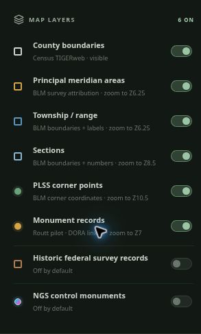
- Check the layers. Under Map Layers, leave Principal meridian areas and Township / range enabled, or turn them back on if you disabled them.
- Zoom closer for context. Meridian shading starts around zoom 6.25 and is hidden at closer scales; labels appear at their own zoom levels. Read the available township labels and meridian attribution together.
- Inspect the intended point. Review the available survey identifiers and, where calculated, the DORA search reference. Confirm these against the intended area and source records, especially near survey-system boundaries.
- Continue to the official records. The protected DORA workflow uses available or calculated search fields. The GLO action opens a research pathway where you carry the references into the official search; it does not promise an automatically matched or prefilled GLO result.
The underlying BLM Colorado township dataset is a GIS representation compiled from survey and other source information. Use it to orient research, then verify the documents. If no detail appears, check the zoom level and source coverage before drawing a conclusion about the land.
Check the layer.
Then check the zoom.
Principal meridian areas and Township / range start on.
At statewide scale, the controls prompt you to zoom closer. Meridian shading and labels have scale limits to keep the map readable.
Free Map Viewing vs. PLSS Pro
Anyone can open the map, pan, zoom, toggle the meridian and township layers, and inspect available point information without an account. Public government records also remain available through their official portals.
PLSS Pro unlocks protected record actions in the research panel, supported KML downloads, and routing/navigation tools. Attempting a protected action as an anonymous visitor displays account and plan options. Creating a free account alone does not unlock Pro features.
Map coordinates and KML files support orientation and research planning. They do not replace the controlling survey evidence or a properly specified field-control workflow. Our guide to NGS control monuments versus PLSS corners explains that distinction.
Start with the Complete Survey Reference
Before searching, carry forward the state, principal meridian, township number and direction, range number and direction, and relevant section or survey identifier. This is a practical way to reduce avoidable search errors while keeping the map and source documents connected.
Use the Colorado section-corner research guide to continue from geographic orientation to monument-record research.
Open the Colorado PLSS Research Map to inspect the principal-meridian context and put the six-guide series to work.